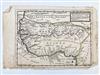
EARLY 18TH CENTURY MAP OF WEST AFRICA. Copper engraved and hand-colored map titled "Negroland and Guinea, with the European settlements, explaining what belongs to England, Holland, Denmark &c. By H. Moll Geographer. 1728." Published in London by "Thos. Bowles and John Bowles" and by cartographer and engraver Herman Moll (British, 1654 - 1732). Unframed. Estimate $250-350