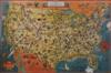
GROUP OF TRANSPORTATION MAPS: CARS, BUSES AND PLANES. "Map of the Old Spanish Trail", National Highways Association, Washington DC, 1928, showing the Old Spanish Trail, or Santa Fe Trail. "Historical Flight Map with Chronological Review of Aviation History" published by Rand McNally c.1928; "A Good-Natured Map of the United States Setting Forth the Services of the Greyhound Lines and a Few Principal Connecting Bus Lines, pictorial map by The Reserve Litho. & Ptg. Co., Cleveland, c.1920. Estimate $300-500
PROVENANCE: Collection of Andrew M. Modelski, Library of Congress (Retired) Consultant. Former head, Acquisitions Unit, Principal Recommending Officer, Geography and Map Division
Old Spanish Trail: 3 in. losses at bottom left and bottom right margin, also 2 in. loss at lower left margin, folding creases. Flight Map: Folding creases. Greyhound Lines: 2 in. loss below Florida peninsula, small losses at bottom left corner folding creases.